By Ooi Kee Beng. Penang Monthly editorial June 2023
HISTORY seldom follows a distinct and predictable line of events. Contingencies, serendipities, good luck and bad luck, all come into play. Naturally, therefore, how polities interact with geography over time leaves behind legacies and perspectives which do not necessarily act to their best advantage. In fact, these probably limit how we, in the present, think about our limitations and our possibilities, and how we decide on our key values and our pet distastes.
My article this month wishes to highlight this with regard to present-day Penang and its geopolitical past—and present. More to the point, I wish to narrate the State of Penang in terms of a state connected by the sea in its midst rather than one divided by it. The notion of economic and cultural division regarding the island and the mainland has clear geopolitical historical origins, and that division today is preserved by the two being managed as two separate city councils. Even voter preferences split these two regions, as do their distinct socio-economic realities.
Working against this legacy of separation requires that we revisit its geopolitical and socio-anthropological origins. Allow me an attempt at this today.
Island and Mainland
The fact that the territories constituting what is the present-day State of Penang was occupied by the British in two stages continues to bear profoundly on how its population experiences the cultural geography of the place to this day. The island was officially settled by the English East India Company on 11 August 1786, just ahead of Dutch movements northwards from Melaka, seeking to gain a monopoly over tin supplies coming out of Selangor, and to ensure an expulsion of all other Europeans from that sultanate.
Having failed to gain military support from the mistrusted European powers to limit Siamese expansionism in the peninsula, and with the lure of sacking Penang to tempt mercenaries, a military alliance of sultanates under Kedah was formed. A gathering of sea warriors spearheaded by lanuns from the Sulu islands thus ventured forth from the south to attack Dutch assets in Perak and Selangor, and finally the British newly lodged in northerly Penang. For reasons still unclear, the Malay armada that gathered on 26 November 1790 off the Prai river mouth in a face-off with British vessels did not attack but, instead, left for Kuala Muda, the Kedah River mouth. An unexpected intrusion into Kedah further inland by the Siamese appeared to have been what drew the fleet upriver to meet this unexpected threat from the north.
The following four to five months saw preparations for confrontation—accompanied by negotiations—by both sides of the Strait of Penang.
The British dispatched from Calcutta “two complete companies of Native Infantry”. In the battle that ensued in the form of a dawn attack on 12 April 1791 on newly-built Kedahan forts at the Prai river mouth, these Sepoys played a crucial role in destroying the forts and scattering Kedah’s perahu-based navy. By 16 April, the battle was over.
Sultan Abdullah sued for peace the following week, requesting a payment of 10,000 Spanish dollars per annum to end all the mutual quarrels. He settled for 6,000 Spanish dollars, however, and the treaty that ensued avoided any mention of military assistance from the British.
That figure was raised to 10,000 Spanish dollars per annum in the treaty signed in 1800 between Sultan Dziaddin Mukarram Shah II of Kedah and Penang’s first Lieutenant-Governor, George Leith (Francis Light having passed on in 1794), wherein the territory opposite Penang Island was ceded to Penang. This 60-square-mile coastal strip of buffer territory became known as Province Wellesley. Now having full control over the port, the Settlement of Penang, as the joint territories were now called, could allow for free trade from and to Kedah and the rest of the world. What Kedah got out of the deal, at this very beginning phase of the rise of the British Empire in the Far East, was a minimised threat of sea attacks from other powers, regional or European. (Slight adjustments to the borders of Province Wellesley would be made in 1859 and 1874).

The growth of the port of George Town in population size, economic prowess and administrative relevance in the early decades is legendary. By 1801, 25 years after being settled, Penang Island had an official population of 10,310, not counting Europeans and members of their garrison. The figure was probably underrated, but officially, this was already a jump of 3,400 from the 6,937 recorded just four years earlier.
Penang’s strategic importance to the British soon grew more and more obvious, leading to it becoming the Fourth Residence of India in 1805. This prestigious status was to end rather quickly with the founding of the better-placed settlement of Singapore in 1819, the signing of the Anglo-Dutch Treaty in 1824 dividing Sumatra from the Malay Peninsula administratively, the forming of the Straits Settlements in 1826 albeit run from Penang for four years until its Residency status was annulled in 1830, and ending with the Straits Settlements being managed from Singapore in 1828.
Be that as it may, Penang as a British settlement developed rather well. In 1894, its iconic ferry system for cars and pedestrians was in place, thanks to local tycoon, Quah Beng Kee. Over the years, life in Penang was peaceful and promising despite some economic downturns and epidemics… at least until 1941.
Province Wellesley as a buffer against attacks did not help when the Japanese arrived that year. They invaded Malaya on 7 December, two hours before Pearl Harbour in Hawaii was bombed, and within a week, the British and Australian airbases in Butterworth had been wiped out. By 19 December, the settlement had fallen into Japanese hands, the European population having quietly fled to Singapore, leaving the local population to its own fate.
Another Geopolitical Shift
In effect, this marked the demise of the Straits Settlements, albeit that it officially ended only on 1 April 1946. Singapore became a crown colony on its own while Penang and Melaka went on to form parts of the Malayan Union. (This copied and continued the Japanese administrative separation from 1942 to 1945 of Syonan-to (Singapore) from Marai (Malaya). The Union’s dismal failure saw Penang taking on a minor role within the Federation of Malaya.
Thus, conceptually, the State of Penang or Negeri Pulau Pinang, once called Prince of Wales Island, then the Settlement of Penang, was now a solid political unit functioning as a state among 11 others. Today, it is one of 13 in the Federation of Malaysia.
The resistance in Penang against being subsumed under peninsular politics, though almost always a silent one, is reminiscent of what was to happen to Hong Kong 40 years later, when that colony was returned to its mainland polity. In the case of Singapore, that subsuming process totally failed, and Singapore had to go its own way by 1965 as an independent polity.
This new reality for Penang was a sudden one, both bewildering and welcomed at the same time. Necessarily, it did lead to political reorientations and some degree of chaos. Politically, the ending of local elections allowed for the state government to exert power as the lower level of governance; and economically, the annulment of its free port status left Penang without its major source for growth.
Being a well-situated port, Penang’s economy, at least until the 1960s, had depended on entrepôt trade, on international travel between West and East, and generally on its role as a key node in Britain’s colonial network, taking full advantage of the fact that it lies at the eastern end of the Indian Ocean, the southern edge of the Andaman Sea and the northern tip of the Straits of Melaka.
These times of turmoil saw the political opposition led by Lim Chong Eu taking power in 1969, with its greatest achievement being the establishment on Penang soil of free trade zones; these took full advantage of the revolution in electronics taking place globally at that time.
These free trade zones are found on the mainland and on the island. With a thriving port and airport, the factories are well served and well connected to world markets today. The first bridge was opened in 1985, and the second in 2014.
Is it still possible today, then, to think of the mainland as being subsidiary to the island? What else is needed to make them notionally whole, in the mind of even the most insular islander? Using the sea in between the way people in Hong Kong do would help.
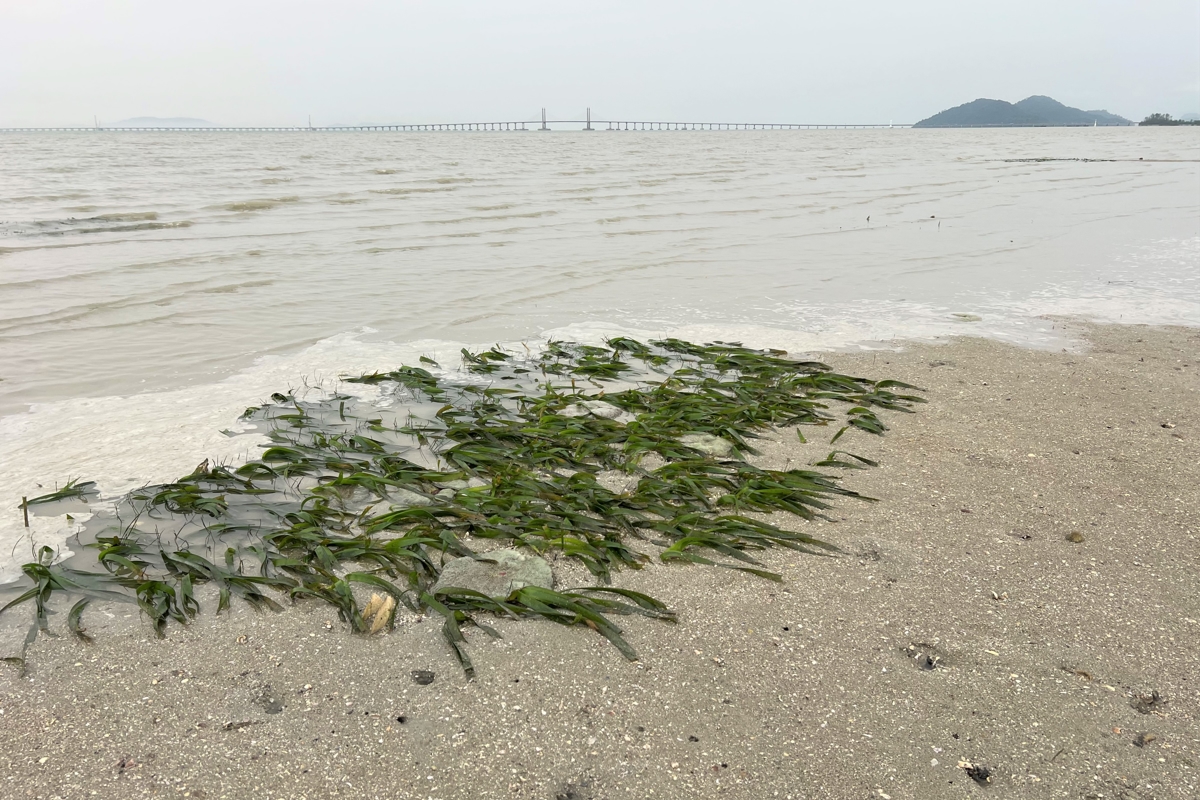
Perhaps if we begin to turn our cultural consciousness to the surrounding seas, as people of the Nusantara have been prone to do? And especially to the watery heart of the State of Penang itself, where there lies land visible only when the tides are very low? To Middle Bank?
Penang’s Marine Heart
Middle Bank is a sandy ridge bordered by rich and nourishing mud, lying off the east coast of Penang Island. (See features in Penang Monthly August 2021, September 2021, January 2022 and June 2023) It has always been ignored by Penang’s land-dwelling policymakers on both sides of the Penang Strait.
If preserved and gazetted as a marine sanctuary, as has been suggested by Penang Institute and which the Penang State Government has agreed to do, Middle Bank can fulfill a multitude of positive functions. Not the least of these is for it to belong to both island and mainland.
Since Penang today is simply two cities separated by the Strait, if part of that Strait is highlighted as a sanctuary for marine life, marine research and experiential tourism, it would hold the two parts together.
It draws our gaze out into the sea again, and in raising our consciousness about the wealth of our coasts and the Strait itself, we will see the Middle Bank Marine Sanctuary as the open space for relaxation and inspiration that self-respecting cities should have. Fittingly, Penang’s Central Park will be a marine reserve.
It can be that wide open space at the wet heart that we can observe in wonderment from the two urban halves of Penang.

Discussion
No comments yet.